Strong storms will hit the southern United States with dangerous flooding and possible tornadoes
(CNN) — A storm is approaching across the southern United States, opening the door for significant flooding, damaging winds, hail and possible tornadoes to hit the region through Saturday.
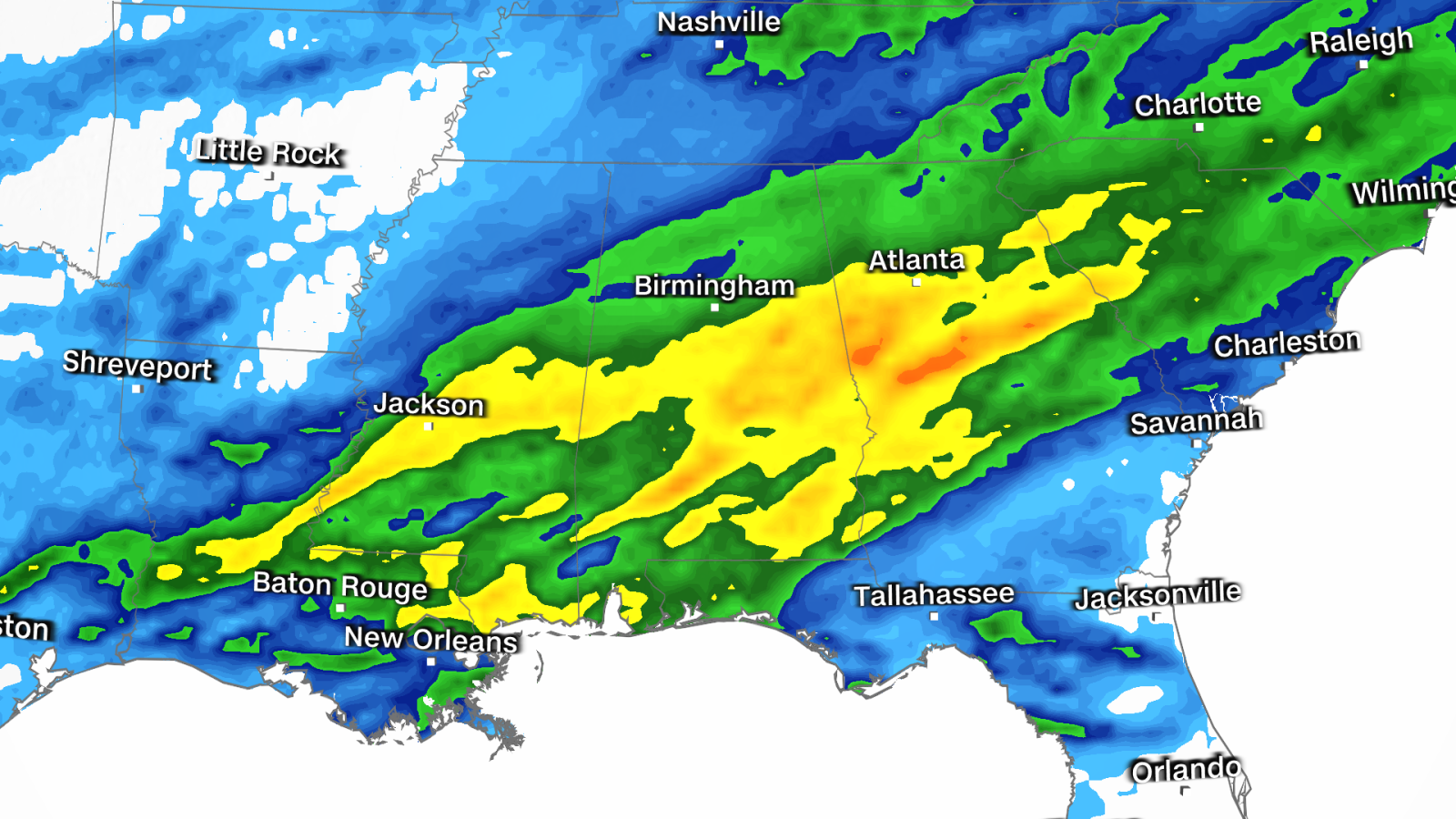
Flood watches are in effect for about 15 million people in the south — including parts of Atlanta — as storms focus on the region.
Here’s how the threats will play out over the next two days:
Friday: Risks for severe thunderstorms and flooding expand
A widespread threat of severe thunderstorms and significant flooding will develop from the southern Plains to the southeast as the same storm that brought severe thunderstorms and hail to parts of Texas and Oklahoma on Thursday strengthens and moves eastward.
Storms that developed Thursday night continued into parts of Texas Friday morning, while another area of storms sprung to life in parts of Louisiana, Arkansas, and Mississippi.
These storms will continue to develop, strengthen and slowly move eastward during the afternoon and evening hours. During the same period there will also be an increase in heavy rainfall, both within and outside the damaging storms in eastern areas.
Hail, damaging winds, heavy rain and tornadoes are possible, especially in the afternoon and evening. A tornado risk covers a wide area from Texas to Alabama and parts of Florida.
Shreveport, Louisiana; Jackson, Mississippi; and Mobile, Alabama, are some of the cities under a Level 2 of 5 threat for severe thunderstorms this Friday, according to the Storm Prediction Center.
Flood risk levels are 3 out of 4 for parts of Alabama and Georgia, including parts of the Atlanta metro area. Atlanta already experienced major flooding Wednesday after 3 inches of rain inundated the area.
Heavy rain by late Friday evening could bring an additional 3 to 4 inches to the Atlanta area and create a new round of dangerous flash flooding.
A level 2 out of 4 flash flood threat is in place for parts of Louisiana through Tennessee and the Carolinas. Widespread rainfall of 1 to 2 inches is possible and could lead to flash flooding.
Saturday: Stormy weather to the east
Powerful storms will spread across much of the East this Saturday, with severe storms and flooding the following day.
The highest risk for severe thunderstorms will once again be centered over the southern United States. Damaging storms from Friday night are expected to continue into Saturday morning across parts of Alabama, Georgia and Florida.
Additional storms could also revive and move toward the Carolinas as rising temperatures provide an additional boost of energy Saturday afternoon.
Damaging winds, flooding and a few tornadoes are expected to be the main threats associated with Saturday’s powerful storms.
Farther north, the storm will drop torrential rain over the Great Lakes early in the morning and reach the Northeast by Saturday afternoon. Saturday night could change to a wintry mix of rain, snow and ice across the interior Northeast.
After days of active weather, the storm is expected to move out of much of the East on Sunday and allow drier conditions to set in. However, some rain and a wintry mix may persist in New England.
:quality(70)/cloudfront-us-east-1.images.arcpublishing.com/elimparcial/RL2ZUAUDH5EBZDMWO4Y5Q5KNYA.png)
:quality(85)/cloudfront-us-east-1.images.arcpublishing.com/infobae/TR2CF6BZIZLZKTVHBEO6SGOJ4I.jpg)
:format(jpeg):focal(1495x325:1505x315)/cloudfront-us-east-1.images.arcpublishing.com/gfrmedia/H5ED4EW2YBHBZGTZGVAV5WFPBM.jpg)
/cloudfront-eu-central-1.images.arcpublishing.com/prisa/Q3XAFIJ6XJFG5IAI6KMJMPOFLE.png)
:quality(70)/cloudfront-us-east-1.images.arcpublishing.com/elimparcial/OBTSSDLOTJCETNO3LRCFS2FB3E.jpg)